Showing posts with label Driving Alaska Highway. Show all posts

Friday, August 19, 2011

On the road... a long way from home... Aug 16-19

Tuesday Aug 16 - Friday August 19

We left Skagway after I did some shopping and Tom did the laundry.  I got myself a Chilkoot Tee shirt and a photographic print of the Golden Stairs during the winter of 1898 and a bear paw bead for my Pandora bracelet as well as a little something for my kids.  I also went to see Tracy, a friend of Peter's who is doing an internship at the Westmark hotel in Skagway.

The drive out of Skagway was beautiful.  It would have been a whole lot more gorgeous had it not been raining AGAIN!!  But this is coastal Alaska so I do understand.  The drive up through the coastal mountains was beautiful there were uphill grades of up to 11% (one reason we drove to Haines and took the ferry from there to Skagway.)  We camped Tuesday night at a place on the Alaska Highway right near the continental divide.  They promised wi-fi... HA!

Wednesday we turned down the Cassier Highway, it was like a roller coaster at first, just chock full of frost heaves, but then it settled down.  There were sections that were very beautiful where we were still driving through avalanche zones in August.  The mountains rose straight up from near sea level to almost 4000 ft in some places.  The place where we stayed (also promised internet at $1/megabyte - HA!) It was pretty but we camped in the middle of a lake.  I mean that our trailer was in the middle of the lake.  But they had really nice showers so I guess that made up for the muddy mess.  This place was a center for heli-skiing in the winter, they must just get an amazing amunt of snow with all of the coastal moisture.

Thursday morning we turned off the Cassier Highway and headed toward Steward, BC and Hyder, Ak. This was to be out last stop in Alaska.  Steward seemed like an ok town, but Hyder???  Sorry to any Hyderians, but this was the biggest pit I have ever been to.  There is not one inch of paved road in the town, not even a gravel road, not even a dirt road...just all mud.  Once we crossed the US-Canadian border it was like going back in time 100 years, and not in a nostalgic kind of way.  But in the Tongass National Forest, there was supposed to be an awesome bear viewing place along the stream where the salmon were running.  I was exhausted, really, exhausted at this point and decided to have a hissy fit, a Kate kind of hissy fit... and only those that know me well have ever experienced one of them... Enough said!  There were no bears, I was tired and didn't want to wait 6 hours to see bears. I've seen anough bears for one summer.  After waiting 2 hours, (me sleeping in the camper) we finally left and said goodbye to Alaska. We drove as far as Smithers, BC.

Smithers actually felt like we were back in civilization.  There were real stores in town with names that I recognized and it wasn't raining for a change (at least for a short while).  There was only one place to camp in town and that was at a municipal campground.  It looked pretty nice and they promised free wi-fi (RIGHT!!)  I decided that when I have cell coverage, I am in or near real civilization.  Of course, it still rained...

Friday morning we left the campground and picked up a few groceries in Smithers at a Safeway and headed East.  It feels really good to be heading home.  We figured that groceries will be pricey in Jasper and Banff but we haven't had any fruit available for so long.  Tomatoes in Alaska were $3.00 each and even more expensive in the Yukon.  I got tomatoes, peaches, blueberries, apples and bananas :-)  Today we drove as far as McBride, BC (about 2 hours from Jasper) we're right at the base of the mountains on the Frasier River.  We are finally at an awesome campsite with wi-fi (YES!!!) that actually works :-).  I was finally able to get my tent dried out from the Chilkoot trail after packing it up wet on Monday since we've had rain everyday since at least in the evening while we're in camp.

I'm looking forward to seeing Jasper and Banff and getting a little hiking in, but I'm excited about getting home and seeing my kids and dogs and friends.  I'm even looking forward to a little heat and humidity.   Today was the hottest day I can remember since we 1st got to Wrangle-St Elias NP and the high today was 66.  We've had to have the heat on every night it's been so cold, in the hi 30's or low 40's.


Views from the highway coming out of Skagway
 Fireweed - my favorite wildflower
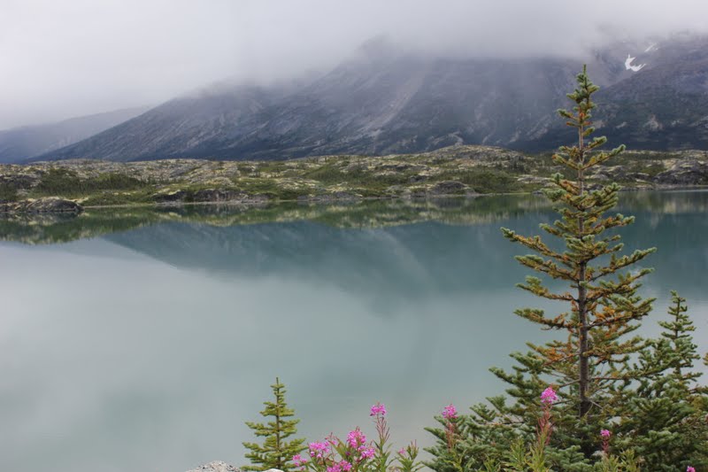
 Just east of the Alaskan-Canadian border in British Columbia


Wednesday, August 10, 2011

Haines and preping for the Chilkoot Trail


Haines, AK - Aug 8-10

We’ve spent the last couple of days in Haines, Ak  After arriving on Monday, we found this really cool spot along the Chilkoot River that bears like to frequent.  In addition to the bears, it is just plain beautiful here.  Chilkoot Lake is a snowmelt and glacier melt lake that feeds the river and right now the salmon are running by the thousands therefore the bears are also frequenting the river.  The fishermen are after the trout since salmon don’t feed once they hit fresh water. Alaskan citizens can dip net for salmon, meaning that they can just stick a big, really big net into the water and pull out salmon.  Think pulling fish out of an aquarium with a net, but only on a much bigger scale.

Haines is a nice, quiet little town that is the 1st stop on the Alaskan marine highway where one can actually get to the Alaskan highway and into mainland Alaska.  There is also a cruise ship stop here on Wednesdays.  It isn’t a typical cruise ship town in that they don’t have all of the jewelry stores, souvenir shops, etc.  I have enjoyed the past couple of days, just chilling and getting our packs ready for the Chilkoot Trail that we start tomorrow morning.  Honestly, I am terrified!  I am not in the kind of shape I need to be to do this hike; my boots aren’t broken in enough, my pack weighs way too much, but it is now or never.  At the very least I can try and fail or not try and never known if I could actually do it.  There really isn’t anything that I can eliminate from my pack to lighten my load since the nighttime temps will be dipping down into the 30’s and we are pretty much guaranteed rain.  At least some of my food will be gone by day 3 which will be the most challenging of the 5 days.  Much of the hike on day 3 is at a 45-degree angle through a boulder field.  The 8.5 miles typically takes 10-12 hours. I am thinking it will be probably the biggest physical challenge that I have ever attempted.  Thursday will be about 8.5 miles, Friday about 4.5 miles, Saturday (please pray for me day) 8.5 miles, Sunday 8 miles, and Monday 4 miles.  At the end of the trail at Bennett Lake, the White Pass & Yukon Railroad has a depot and we will have a big lunch there and take the train back to Skagway.  Hopefully the weather will be good because they make the backpackers ride in an outdoor car. I can totally understand this!  If I were a tourist I don’t think I would want to sit near me after 5 days on the trail either.  Once back in Skagway and after a long hot shower, a couple of beers and a good night’s sleep we will begin the long trip home.

From Skagway, we will go back into Canada and drive the Cassier Highway south through British Columbia, then head east on the Yellow Head highway into Alberta to Jasper and Banff, then time allowing down to Glacier before crossing the border in Montana and booking it home through ND, MN, WI to arrive back in Ann Arbor on August 27 with plenty of time (2 days) to get ready to go back to work.

For more information on Chilkoot Trail and the Goldrush National Historic Site, see http://www.nps.gov/klgo/index.htm.  


 Hey! What happened to that fisherman?


The Golden Staircase on the Chilkoot Trail (day 3) during the goldrush

Monday, August 8, 2011

Close encounter of the BEAR kind!!

August 8...  Happy 22nd birthday Hanna!  I miss you!!

Yesterday we drove from Fairbanks to Haines Junction, Yukon.  Haines Junction is the gateway to the Kluane National Park of Canada.  It is an awesome area and is a UNESCO World Heritage Site.  It backs up to Wrangell-St ELias National Park in the US (our largest national park).  I liked Haines Junction except for not having any cell service.  We had a trail head into Kluane NP right in our campground :-).

Today we drove down to Haines, AK, making yet another US-Canada border crossing.  It was a beautiful drive even with overcast skies.  The border patrol guy was really nice and had Tom fill out some extra paperwork so the halibut that he caught in Homer wouldn't be confiscated when we cross the border into Montana in a couple of weeks.  Much different from the border agents on the bridge to WIndsor!

Haines is a great little town and very friendly.  We are in a nice little water front campground, the owner lady is very sweet and is a gem at directing people backing up campers, BLESS HER HEART!!  I love the smell of the ocean and watching the fishing boats come in with their catch.  An added bonus today is that the salmon are running on the Chilkoot River just a few miles down from the campground and the bears were out feeding.  I was able to get some shots of a sow with her twin cubs that are in their 2nd summer.  After watching them for awhile, they came right up on the road, I kid you not, they were 5 feet from Tom's truck.  Wow to watch people scatter!  There was an Alaska Parks Ranger there and when the bears started coming close to shore, the ranger asked everyone to move back and let the bears pass.  I was IN the truck by that point!  There is a short section in the road where people are not allowed to walk or stop their vehicles so the bears can walk up the road to the fish wier.  A fish wier can be different things but is used to block the passage of fish, in this case it is a fence of wooden slats meant to slow the progress of salmon going out to the ocean so the Alaska Dept of Fish and Wildlife can get an estimate of how many salmon will return to to the river to spawn in 5 - 7 years.  The bears love it since they can hang out by the fence and easily catch fish.  But when we saw them they were out in the open river actively catching fish.  The wier does come down before the salmon run in the fall when the the mature salmon are returning from the ocean to spawn.

To top off a very good day, we went to the outskirts of town (ok, so Haines is really a mini skirt so we didn't have to go very far) to a place called Dalton City to visit Haines Brewery.  Dalton City was built as the set for the movie White Fang and it has since been taken over by small businesses from Haines.  There was the brewery, the Klondike Restaurant, a knitting shop, a massage therapist and a couple of other places.  Speaking of movies and tv, as we were coming into town, we saw the area where part of the show Gold Rush was filmed, Porcupine Creek...  All very cool.

Tomorrow we're on standby to go on a fjord trip to Juneau for the day, 90 nautical miles.  I'm guessing that we're not going to get on the trip so we'll have to find something else exciting to do.  Wednesday evening we're taking the Alaska Marine Ferry from Haines to Skagway.  It's only 15 miles but will save us about a 350 mile drive around the mountains.  On Thursday, we start our 5 day backpacking trip on the Chilkoot Trail out of Skagway.  Then we will begin the trip back to Michigan...

Kate

 Sow and her yearling cubs fishing the Chilkoot River
 Alaska Range between Fairbanks and the Yukon border
 Glacier on the way into Haines, Ak
 Cub waiting for salmon

 Momma bear

 Cubbies


 Chilkoot Lake
Dalton City from the set of White Fang

Saturday, August 6, 2011

On the Road Again… August 6

On the Road Again… August 6

Today we slept in a bit and visited Pioneer Park in Fairbanks.  It is the Alaskan equivalent of Greenfield Village in Michigan or Sturbridge Village in Massachusetts.  They had a lot of old Alaskan cabins, hotels, brothels, things from years and era’s gone by that were moved to the park in Fairbanks.  It was interesting and we spend just a short time there.

We headed back on the Alaska Highway to complete the short stretch that we missed on the way up when we hit the Glenn Highway to get to Wrangell-St Elias National Park.  We even got a certificate for completing the highway, well we had to pay $1.00 for it.  The highway officially ends in Delta Junction, AK at mile post 1422.  I must admit that the driving conditions were much better than what I expected!  Other than the frost heaves, the road was in great condition.  We are good at predicting where we needed to slow down based on the landscape.  Anytime we see black spruce trees that looked half dead and half falling over, that definitely means permafrost is underneath.  Those  “forests” are called drunken forests because the frost heaves have also displaced the roots of the trees.  The roots are very shallow since they can’t get below the permafrost.  Some of the trees can be 50 to 100 years old but are only a few feet high due to the poor soil and short growing season.  I was able to look at the growth rings under a magnifying glass, it was amazing how little they grow annually.

We had originally planned to stay in Tok tonight (the place where we had the awesome breakfast with the reindeer sausage) where we stayed on the way up, but it was a beautiful day (finally) so we kept driving.  We are in Port Alcan, of course you’ve never heard of it!!  It’s right on the US-Canadian (Yukon) border and is nothing more than 2 gas stations a couple of campgrounds and the border crossing.  We have to go back through Canada to get to the Alaskan panhandle.  Tomorrow night we plan to stay in Haines Junction.  First thing Monday morning we’ll call the Alaska Marine Highway to see if we can get a ferry from Haines to Skagway (only like 20 miles), if we can then we’ll head to Haines for a couple of days.  If not then we’ll head to Skagway.  They are very close together as the whale swims, but far to drive.  If we can get to Haines, we are planning to do a daytrip down to Juneau on a ferry.

Today is the 1st day is 2 weeks where I haven’t had to wear a coat.  The temperature got up to 64.  Yeah!!

Kate

PS My apologies for the poor quality photos - really slow internet...

 Moose antlers - unbelievable heavy
 amazing flowers in Fairbanks
 Mile posts in Fairbanks
 up close and personal with bear claws
 North Pole
 Alaskan pipeline crossing a river (it's 3 feet in diameter)
 Mt Hayes in the Alaska Range

 Finally competes last segment of Alaska Highway

Healy, Alaska to Fairbanks and Chena Hot Springs (Aug 5)

We are into the 2nd half of our 7 week road trip at this point.  Thursday was day 25 of our 49 day journey, we've driven 5300 miles at this point more than half of what we are expecting to drive.  Today we drove from Healy, just north of Denali National Park to Fairbanks.  It was a short drive, relatively speaking.  But nothing here is a short drive!!

I have heard mixed reviews of Fairbanks, but so far I really like it here, much more than Anchorage.  We are in the best campground of the trip so far, that's a blessing considering 2 of the campgrounds that we were in this week in Anchorage and Wasilla that were absolutely horrid.

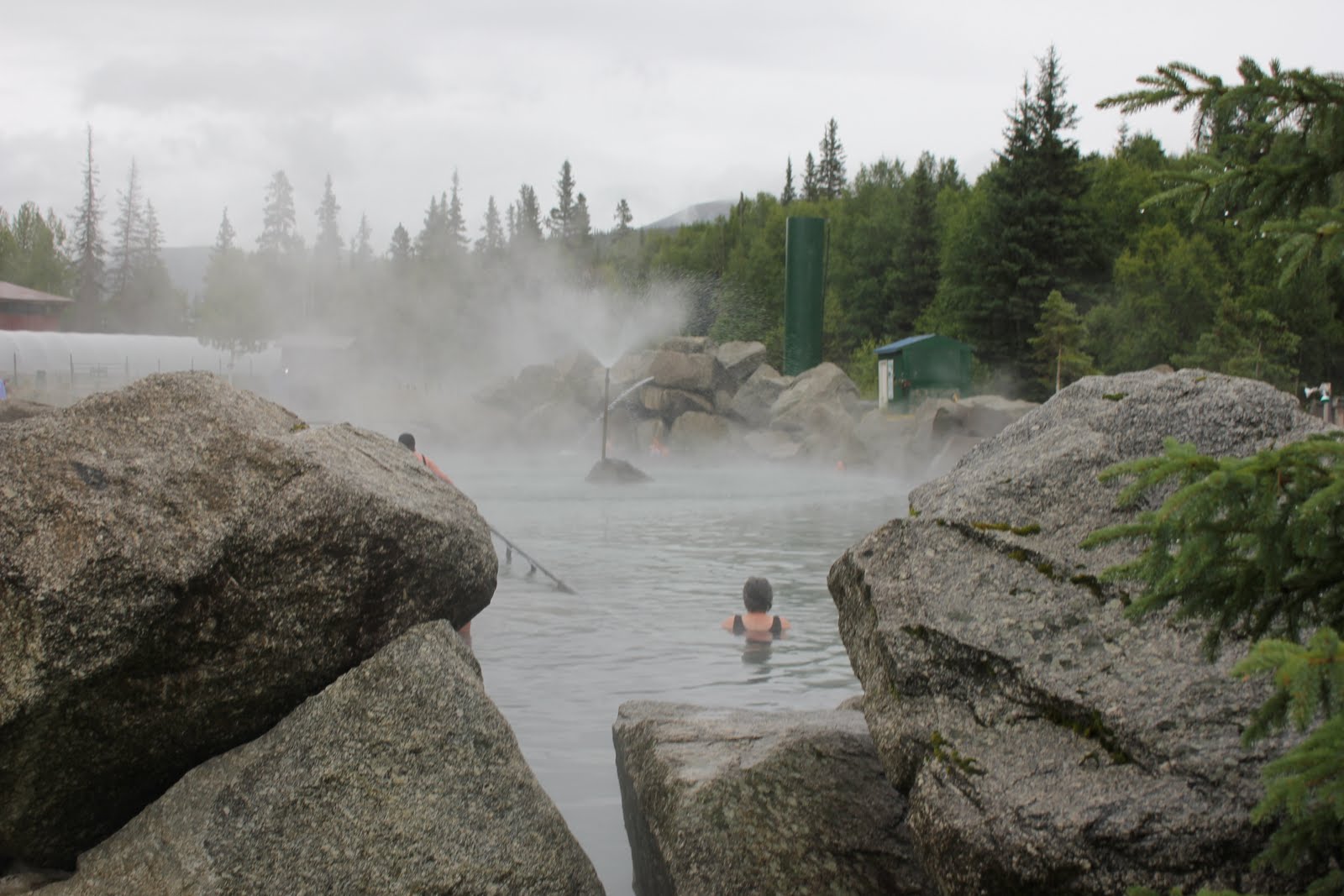
We went to the Chena Hot Springs, about 60 miles northeast of Fairbanks.  These were the best of the 3 hot springs we have visited so far.  Chena is a very cool place.  Not only do they have the hot springs pools, but they also harness the thermal energy to heat greenhouses to grow all of the vegetables for their resort year round.  They get so much sunlight here, much more than the southern part of the state, that the flowers and the summer crops are huge!!  They have a lodge that is over 100 years old.  It's an absolutely beautiful place.  It was a perfect day for the hot springs at 45 degrees.

Tomorrow, we are going to spend a little time in Fairbanks then head back out on the last stretch of the Alaska Highway (Fairbanks to Tok) that we skipped on the way up when we headed off to Wrangell-St Elias NP.  We are hoping to make it to the Tok area tomorrow.


Chena Hot Springs outdoor pool
 Steamy pool-open even at 40 below 0
 Cabin at the Chena Hot Spring Resort
 Amazing flowers - 20 hours of sunlight/day 
More flowers... really pretty place

Sunday, July 17, 2011

Day 6 and 7 on the road... Ft Nelson, BC-> Teslin, YT


Day 6 On the road…  Ft Nelson, BC à Liard Hot Springs Provincial Park (277 miles)

This was an absolutely amazing drive!!  Almost immediately after leaving Ft Nelson, BC civilization as I have always known it ceased to exist except for the Alaska highway.  Any resemblance of a “town” was pretty much non-existent.  There were several towns along the way but they consisted of a gas station, campground and lodge/motel.  Muncho Lake was the largest community we passed today.  There was a gas station there that charged the equivalent of $7.40/gallon for gas… no thank-you!!  But they did have a k-12 school and a few homes in the area.

The drive through the Rockies was spectacular.  This drive is said to be the best and most scenic on the entire Alaska Highway and I can totally believe it!  There was a lot of climbing and descending at 8-10% grade on multiple “S” curves that totally scared the hell out of me.  But then again I don’t care much for roller coasters.  I loved the scenery, the Muncho Lake area the most beautiful to me.  There is a lot of copper in the mountains draining into the lake.  When the copper leaches into the lake it gives it the most amazing blue color.  The highway travels alongside the entire 7 miles length of the lake, it is totally amazing.  We are going to try to camp there on our way back down the highway.

We arrived at Liard Hot Springs around 3:00, quite a short day for us.  This is the 1st time the truck and trailer had to be backed up into a camping spot… YIKES!!  Our site didn’t have a good angle.  A very nice man came along and helped Tom out.  Thank you!!!  Needless to say we were both getting a little frustrated.  No electric and no water today so the set up was very fast and we were off to the hot springs.  There are several pools, the top one was closed because a rare hot water snail was found to be living there.  That is the hottest of the pools at 125 degrees (way too hot for me!!)  The 2nd pool was plenty hot, even for the queen of hot tubs!  I couldn’t tolerate it but the water flowed over a small waterfall into another pool and was amazingly relaxing.  We hung out in the lower pool for about an hour, the further down stream we went the cooler the water.  At the end, I the hung out at the falls with the very hot water running over my neck and shoulders, how heavenly!!!

Wildlife spotted today; stone sheep and bison.

The weather was cloudy this morning and cleared up this afternoon then rained in the evening.  Today has been a super spectacular day, the best so far!! J

Day 7 on the road…  Liard Hot Spring Provincial Park to Teslin,, Yukon (277 miles)  YUKON Territory!!!!

This morning we were on the road by 8:00 AM after going on a short hike hoping to see a moose in the wetlands near the hot springs, no such luck.  Today’s drive was very pretty, some mountains, lots of rolling hills and next to no civilization.  The biggest town we went through was Watson Lake with a population of  987.  We had to pick up a couple of things at the grocery store; sliced deli turkey was $12.20 lb, eggs were $4.95/doz and Campbell’s soup was  $4.19/can, local beer is $14.29/6 pack of cans.  We bought the essentials until we can do some ‘proper’ shopping at Whitehorse tomorrow. 

The excitement of the day is that we saw 3 black bears along side the road.  We noticed that if the side of the road is wide with lots of wildflowers and the sun is out, they seem to be out too. 

Tonight we have a campground all to ourselves, The Dawson Peaks Campground, it is located on Teslin Lakes about 7 miles south of the town of Teslin.  The owners asked us if the highway was closed somewhere south of here today because there was so little traffic.  We had noticed that as well, sometimes it would be a very long time before we would see another vehicle traveling in either direction.

We crossed the continental divide that divides 2 of the largest drainage systems in North America – the Yukon River and Mackenzie River watersheds.  Water draining to the west forms the Swift River and drains into the Yukon River and continues northwest for 2300 miles to the Bering Sea and ultimately the Pacific Ocean.  Everything draining east forms the Rancheria River that flows into the Mackenzie River and empties into the Beaufort Sea (Arctic Ocean) after a journey of 2650 miles (The Milepost 2010).

Tomorrow we are heading to Takhini Hot Spings about a 300 mile drive.  Today we hit the 3000 miles mark, not bad for 7 days on the road.

Kate


Black Bear on the side of the road (zoom lens!!) 

Stone MOuntain Sheep 


 Northern Rockies in British Columbia

 Muncho Lake, BC from the Strawberry Flats campground

Muncho Lake, BC 

Muncho Lake, BC 

Bison on the Alaskan Highway 

 Liard Hot Spring Provinicial Park, BC

 Liard River


 Liard Hot Springs, BC

 Yeah Finally!!!

Sign Post Forest in Watson Lake, Yukon  


 Somewhere in the Yukon

Rancheria Falls